Tüm Denizlerdeki Gemilerin Şuan Bulunduğu Yeri, Geldiği Rota, Gemi tipi Gibi Bilgileri Canlı olarak görebileceğiniz Bir Harita
How ShipFinder works
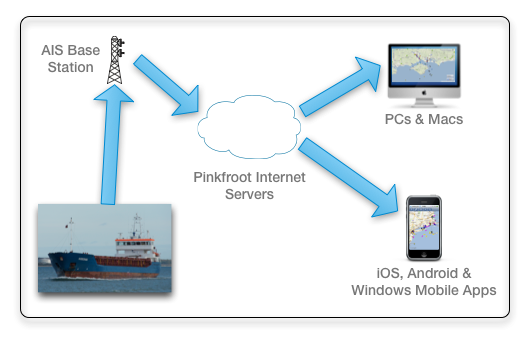
Ship Finder works by picking up AIS ship feeds used by commercial vessels and pleasure craft to transmit their name, position, MMSI, status and lots more.
In summary the system works by:
- Ships broadcast their position via radio signals. (The system is called AIS).
- This information is picked up by our receivers in the area.
- The receivers send the data across the internet to our servers.
- The map you are using gets its data from these servers over the internet.
Our servers add additional information such as route history and photos for presentation on shipfinder.co and in our Ship Finder apps.
The AIS data comes to us either from our own receivers or from people with receivers who share their data with us over the internet. If you are a marine professional or AIS hobbyist we’ll be delighted to receive your data for use within the app. For more details on how you can help please see our coverage page.
We know that this website and the apps are used by a huge range of people including professionals such as port pilots and dockside workers, by ship spotters and maritime enthusiasts, and by anyone who just wants to track a friend or is curious about the ships and yachts out on the water.
We hope that you enjoy Ship Finder however you use it!
For those interested more detail is provided below…
What is AIS?
AIS (Automatic Identification System) is an International Maritime Organization (IMO) standard requiring all vessels of 300tons and over, and all passenger vessels, to carry an AIS transponder. This broadcasts information such as vessel name, position, speed and course plus information such as dimensions and the details of the current voyage. The AIS transmitter includes GPS capability for very accurate positioning.
Increasingly many pleasure craft and smaller vessels can also be seen via the AIS systems as the owners are fitting low cost transponders.
The range of AIS reception between vessels is typically 15-20 nautical miles. Land stations with well placed antennas can get data from over 100 nautical miles away. Data can even be monitored via satellite for true global coverage!
What is AIS used for?
AIS was originally intended for collision avoidance.
Ships, yachts etc carrying AIS receivers can pick up all of the local positional information which provides a very accurate view of the movements of all vessels in the area. Navigational aids etc also transmit and can be detected.
Since 2004 the use of AIS data continues to grow and new uses continue to be found – no one could have envisaged a touch screen kiosk running a customised version of Ship Finder at the top of the Spinnaker Tower in Portsmouth!!
There are now a large number of AIS data networks across the world used by port authorities, shipping companies and people like Pinkfroot who present the data via Ship Finder!
Shipfinder.co
The Shipfinder.co website has been implemented in partnership with Something Interesting Limited.
Something Interesting are a professional and passionate development team focused on delivering quality projects. The team like to enjoy what they do, speak like humans and have their client’s best interests at heart. They don’t believe in cutting corners and won’t compromise the quality of their work.